If you’ve spent any serious time on the water, you already know one truth about fishing: the fish live somewhere specific, and sometimes it can be a challenge to find them. They don’t just roam aimlessly waiting to be caught. They relate to structure, depth changes, current breaks, transitions, and seasonal movement routes. The challenge has always been figuring out exactly where those places are before wasting half the day searching. That’s where mapping becomes one of the most powerful tools in a boat, and why LakeMaster charts have become a game changer for anglers who want to fish smarter.
A lot of anglers still underestimate what premium mapping can do. They’ll invest hundreds of dollars in top end rods, reels, tackle, and electronics, but run outdated or generic charts that only show the basics. That’s like trying to hunt mature whitetails with no aerial maps and no scouting. If you can’t see the terrain, you’re guessing. LakeMaster removes the guesswork and gives you a detailed look beneath the surface before you ever hit the water.
Contour Mapping: Reading the Underwater Blueprint
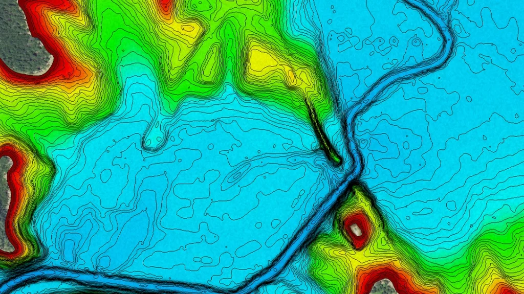
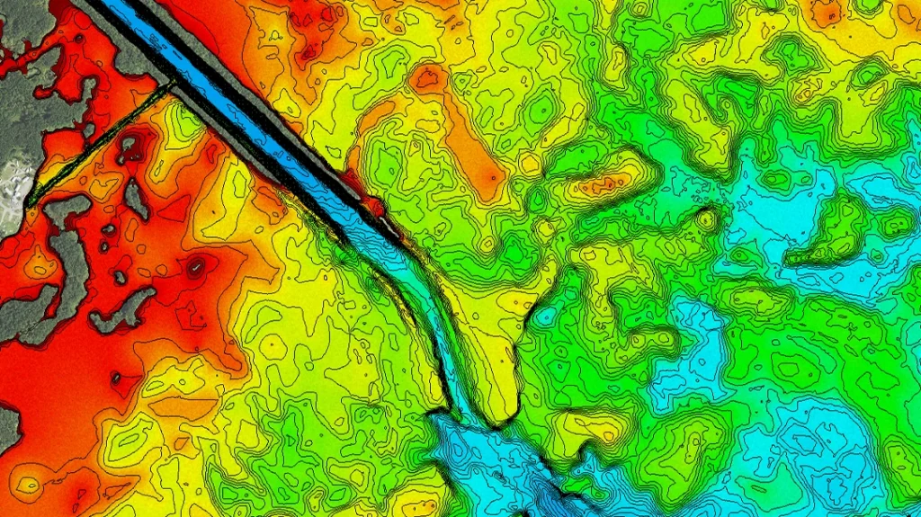
Contour lines are the foundation of serious lake mapping. They show bottom depth changes, breaks, humps, ledges, creek channels, points, flats, and subtle transitions that fish use every season. On lesser maps, those lines may be broad and limited. On LakeMaster, the detail is what separates it. One-foot contours on many lakes allow you to identify subtle changes that often hold fish. Sometimes the difference between a dead stretch of bank and an active stretch is a tiny ditch, a secondary break, or a small hard-bottom rise. Those are the details fish use, and those are the details many anglers drive right over.
Advertisement — Continue Reading Below
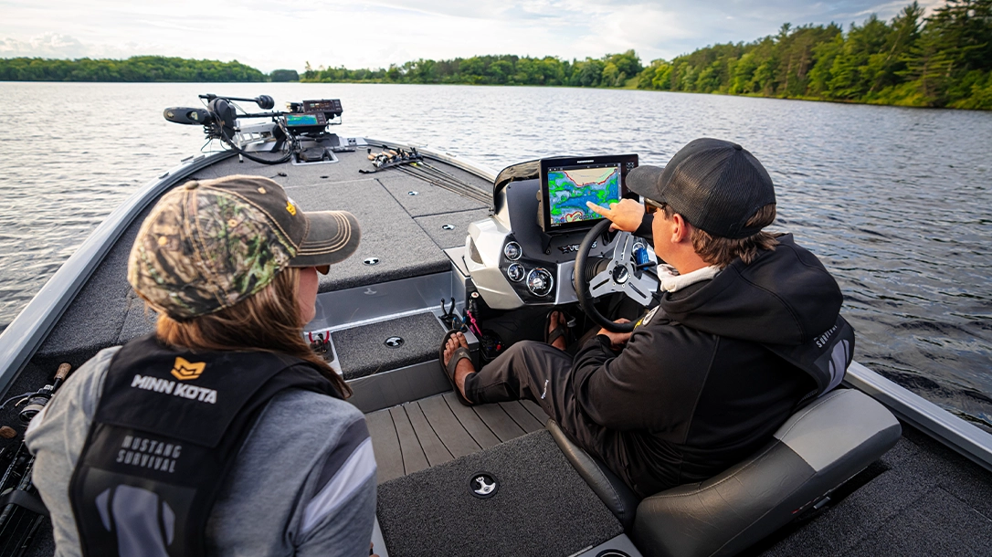
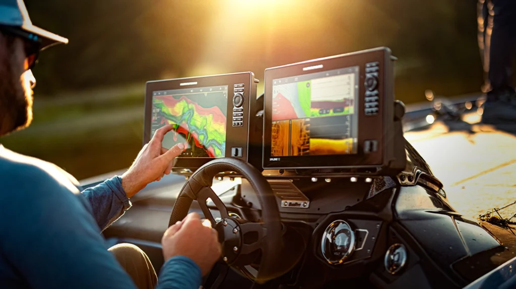
Paired with Humminbird graphs, that information becomes even more valuable. Instead of just seeing lines on a screen, you can use GPS positioning, sonar, and side imaging to confirm what’s happening in real time. When your graph shows a point topping out at 12 feet with bait stacked on the edge, you’re no longer randomly casting, you’re making targeted decisions.
Depth Shading: Simplifying the Search
One of the most underrated features of LakeMaster charts is depth shading. This allows anglers to highlight specific depth ranges directly on their Humminbird graphs. That may sound simple, but on the water it’s a huge advantage. Let’s say summertime bass are holding in 15 to 20 feet of water. Instead of scanning the whole lake and trying to mentally track every contour line, you can shade that range and instantly see every productive zone on the map. Main-lake points, channel swings, offshore humps, and ledges in that range stand out immediately.
Advertisement — Continue Reading Below
The same goes for spring or fall patterns. If fish are staging in 6 to 10 feet of water near spawning pockets, depth shading helps narrow your search fast. Crappie anglers can isolate creek channels and brush zones. Walleye anglers can follow transitions along key depth breaks. It takes complex information and turns it into an easy visual plan. The less time you spend searching dead water, the more time you spend around fish.
Pattern Fishing Gets Easier
The best anglers in the country don’t just catch one fish, they identify repeatable patterns. Mapping is one of the fastest ways to establish those patterns and duplicate them across an entire lake. For example, if you catch quality fish on a windy secondary point in 10 feet of water, LakeMaster lets you quickly search for every similar spot nearby. Instead of hoping lightning strikes twice, this allows you to run the same pattern all day.
Advertisement — Continue Reading Below
Fish often relate to common ingredients: depth, structure angle, proximity to channels, bait movement, and seasonal positioning. Mapping helps you identify those ingredients and duplicate them. With Humminbird graphs, this becomes even more powerful because you can network mapping with sonar tools like MEGA Side Imaging and Down Imaging. You can then find the structure on the chart, scan it for fish or cover, then fish it with confidence. It’s a complete system, not just a map.
Boat Control and Precision
Another overlooked advantage of LakeMaster charts is precision boat positioning. Catching offshore fish often comes down to angle and presentation. Being 20 feet off target can mean missing the sweet spot entirely. Using the map on your Humminbird graph, you can line up on ledges, roadbeds, points, shell bars, or brush piles with exact control. Follow contour lines while trolling. Set up the right cast angle on deep schools. Stay on subtle drains that aren’t visible above water. This level of control creates more efficient casts, cleaner presentations, and more landed fish.
Confidence Wins
There’s also something that doesn’t show up on a spec sheet, confidence. When you understand what’s under the boat, you fish differently. You slowdown in high-percentage areas. You make better casts. You stay patient when you know fish should be nearby. Confidence catches fish, and quality mapping builds confidence.
Advertisement — Continue Reading Below
Modern fishing is about stacking advantages. Better equipment, better decisions, better time management, and better information. LakeMaster charts give anglers a serious advantage by showing what many others never see.
Contour detail reveals hidden structure. Depth shading narrows the search. Pattern replication becomes faster. Precision boat control improves presentations. That combined with Humminbird graphs, turns electronics into a true fish-finding system. At the end of the day, fish will still bite. But when you consistently put your boat around the right water, at the right depth, on the right structure, your odds go way up. That’s why mapping matters and why LakeMaster charts continue to change the game.
Advertisement — Continue Reading Below
WHY OUR ARTICLES/REVIEWS DO NOT HAVE AFFILIATE LINKS
Affiliate links create a financial incentive for writers to promote certain products, which can lead to biased recommendations. This blurs the line between genuine advice and marketing, reducing trust in the content.